The Columbia River is the largest river in the Pacific Northwest region of North America.
The river rises in the Rocky Mountains of British Columbia, Canada. It’s source is Columbia Lake at 820 meters (2,690 feet) above sea level.
It flows from British Columbia through the U.S. state of Washington, forming much of the border between Washington and Oregon before emptying into the Pacific Ocean.
The length of the Columbia River is approximately 2,000 kilometers (1,243 miles).
The Columbia River is the seventh longest river in North America.
With an average flow at the mouth of about 7,500 cubic meters (265,000 cubic feet) per second, the Columbia is the largest river by discharge flowing into the Pacific from North America and is the fourth-largest by volume in the US.
It is also the largest hydroelectric power producing river in North America with fourteen hydroelectric dams in the two nations it traverses.
The drainage basin or watershed of the Columbia River encompasses 668,000 square kilometers (258,000 square miles) of North America, making it the sixth largest on the continent.
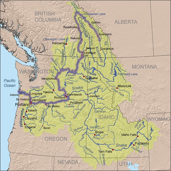
The Columbia River drainage basin includes territory in seven U.S. states and one Canadian province. It covers nearly all of Idaho, large portions of British Columbia, Oregon, and Washington, ultimately all of Montana west of the Continental Divide, and small portions of Wyoming, Utah, and Nevada; the total area is similar to the size of France.
Roughly 85 percent of the drainage basin and 1,200 kilometers (745 miles) of the river’s length are in the United States.
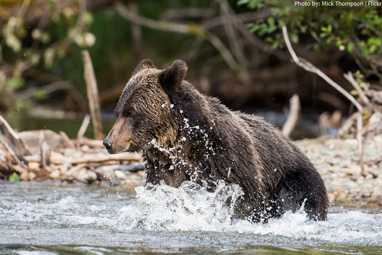
The watershed provides habitat for 609 known fish and wildlife species, including the bull trout, bald eagle, gray wolf, grizzly bear, and Canada lynx.
The Columbia River receives more than 60 significant tributaries. The four largest that empty directly into the Columbia (measured either by discharge or by size of watershed) are the Snake River, the Willamette River, the Kootenay River, and the Pend Oreille River.
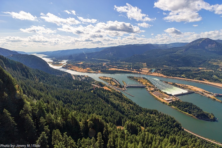
The Columbia River Gorge is a canyon of the Columbia River. Up to 1,200 meters (4,000 feet) deep, the canyon stretches for over 130 km (80 miles) as the river winds westward through the Cascade Range forming the boundary between the State of Washington to the north and Oregon to the south.
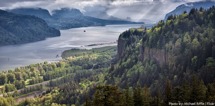
The gorge holds federally protected status as a National Scenic Area called the Columbia Gorge National Scenic Area and is managed by the Columbia River Gorge Commission and the US Forest Service. The gorge is a popular recreational destination.
The historical significance of the Columbia River spans thousands of years in which humans have interacted with the river ecosystem.
Humans have inhabited the Columbia River Basin for more than 15,000 years, with a transition to a sedentary lifestyle based mainly on salmon beginning about 3,500 years ago.
Many different Native Americans and First Nations peoples have a historical and continuing presence on the Columbia.

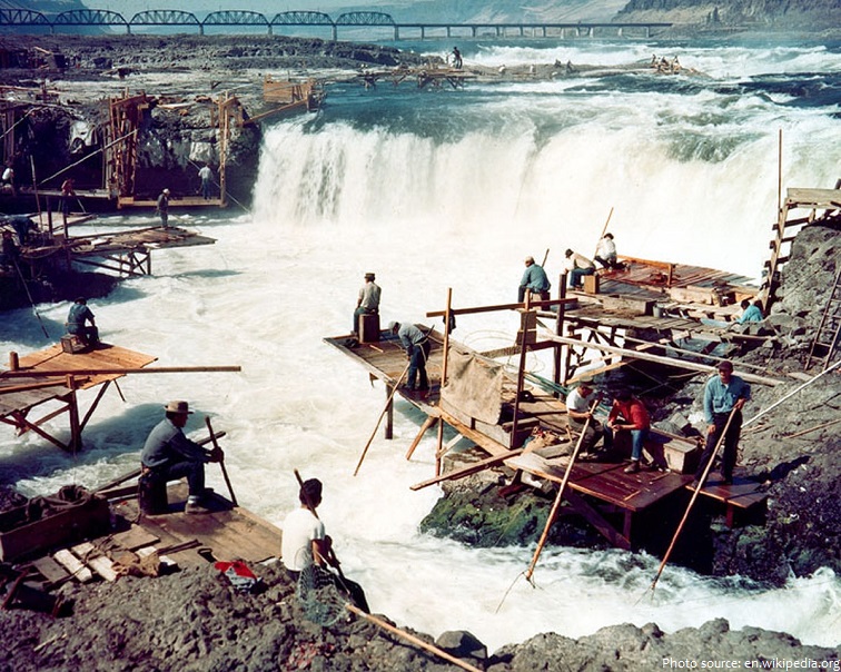
Fish were central to the culture of the region’s natives, both as sustenance and as part of their religious beliefs.
Celilo Falls (Wyam, meaning “echo of falling water” or “sound of water upon the rocks,” in several native languages) was a tribal fishing area. The name refers to a series of cascades and waterfalls on the river, as well as to the native settlements and trading villages that existed there in various configurations for 15,000 years. Celilo was the oldest continuously inhabited community on the North American continent until 1957, when the falls and nearby settlements were submerged by the construction of The Dalles Dam.
The first documented European discovery of the Columbia River was that of Bruno de Heceta, who in 1775 sighted the river’s mouth.
American captain Robert Gray and British captain George Vancouver, who explored the river in 1792, proved that it was possible to cross the Columbia Bar (system of bars and shoals at the mouth of the Columbia River).
The Columbia River was given the name it bears today in May 1792, by American Captain Robert Gray, after his ship, the Columbia Rediviva.
The use of steamboats along the river, beginning with the British Beaver in 1836 and followed by American vessels in 1850, contributed to the rapid settlement and economic development of the region.
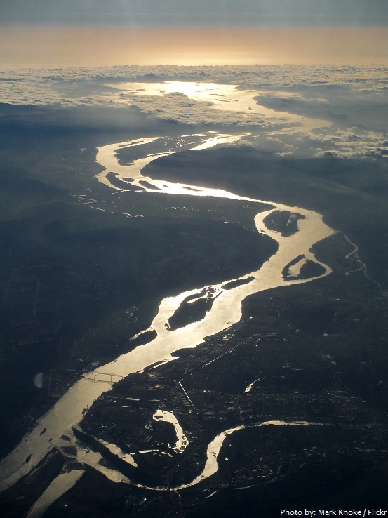
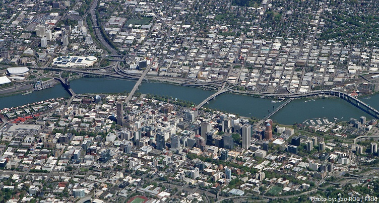
The Columbia River flows through many major cities including Revelstoke, Tri-Cities, Portland [photo below], Vancouver (WA), Longview, and Astoria.
The Columbia River provides drinking water to numerous communities along its course.
Today the main stem of the Columbia River has 14 dams, of which three are in Canada and 11 in the US.
The Columbia River supports several species of anadromous fish that migrate between the Pacific Ocean and fresh water tributaries of the river. Sockeye salmon, Coho and Chinook (also known as “king”) salmon, and steelhead, all of the genus Oncorhynchus, are ocean fish that migrate up the rivers at the end of their life cycles to spawn. White sturgeon, which take 15 to 25 years to mature, typically migrate between the ocean and the upstream habitat several times during their lives.
Dams interrupt the migration of anadromous fish. Salmon and steelhead return to the streams in which they were born to spawn; where dams prevent their return, entire populations of salmon die.
The growth of industries and technology has had a profound effect on the quality of the waters of the Columbia River. Exploitation of the river has led to an imbalance in the chemical, physical, biological, and radiological characteristics of its waters.
Plutonium for nuclear weapons was produced for decades at the Hanford Site, which is now the most contaminated nuclear site in the US.