
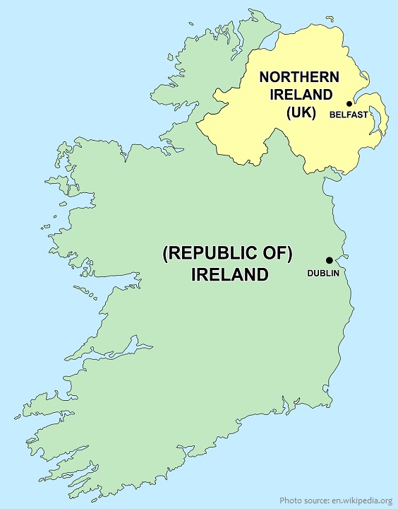
Northern Ireland is variously described as a country, province, or region which is part of the United Kingdom.
Located in the northeast of the island of Ireland, Northern Ireland shares a border to the south and west with the Republic of Ireland.
As of April 2021, the population of Northern Ireland is about 1.9 million people – about 3% of the UK’s population
The country covers a total area of 14,130 square kilometers (5,460 square miles). It occupies about one-sixth of the island of Ireland.
Northern Ireland was covered by an ice sheet for most of the last ice age and on numerous previous occasions, the legacy of which can be seen in the extensive coverage of drumlins in Counties Fermanagh, Armagh, Antrim and particularly Down.
It contains some beautiful scenery, from the rugged coastline in the north and northeast to the gentle fruit-growing regions of Armagh.
Slieve Donard is the highest mountain in Northern Ireland with a height of 850 metres (2,790 feet).
The centrepiece of Northern Ireland’s geography is Lough Neagh, at 391 square kilometers (151 square miles) the largest freshwater lake both on the island of Ireland and in the British Isles.

In proximity to Scotland and to sea channels leading to England and Wales, Northern Ireland has long witnessed generations of newcomers and emigrants, including Celts from continental Europe and Vikings,
Normans, and Anglo-Saxons.
In the 17th century, the period of the so-called Ulster plantation, thousands of Scottish Presbyterians were forcibly resettled and English military garrisons built, arrivals that would institutionalize the ethnic, religious, and political differences that eventually resulted in violent conflict.
Northern Ireland was created as a separate legal entity on 3 May 1921, under the Government of Ireland Act 1920. The majority of Northern Ireland’s population were unionists, who wanted to remain within
the United Kingdom. They were generally the Protestant descendants of colonists from Great Britain. Meanwhile the majority in Southern Ireland, and a significant minority in Northern Ireland, were Irish nationalists and Catholics who wanted a united independent Ireland. Today, the former generally see themselves as British and the latter generally see themselves as Irish, while a Northern Irish or Ulster identity is claimed by a large minority from all backgrounds.
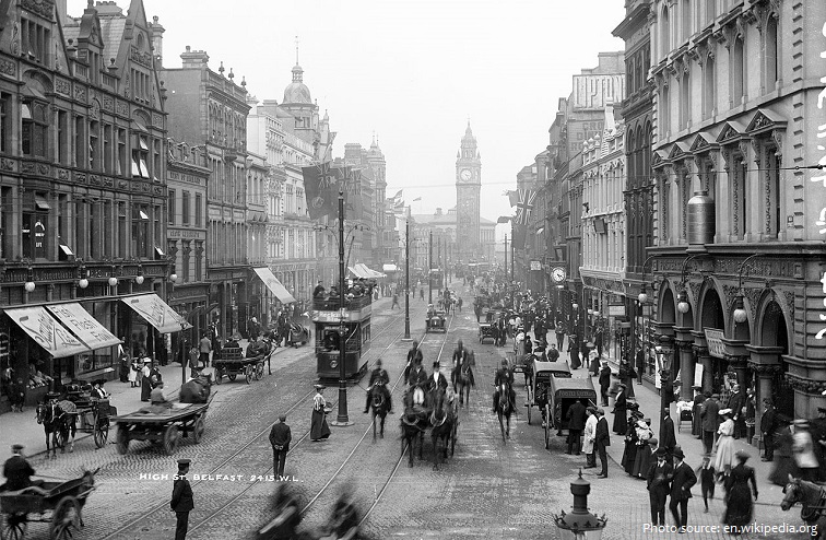
Belfast is the capital and largest city of Northern Ireland, standing on the banks of the River Lagan on the east coast. Belfast suffered greatly during the violence that accompanied the partition of Ireland, and especially during the more recent conflict known as the Troubles: in the 1970s and 1980s it was one of the world’s most dangerous cities.
St Anne’s Cathedral, also known as Belfast Cathedral, is a Church of Ireland cathedral in Donegall Street, Belfast. It is unusual in serving two separate dioceses (Connor and Down and Dromore). It is the focal point of Belfast’s Cathedral Quarter.
The Giant’s Causeway is an area of about 40,000 interlocking basalt columns, the result of an ancient volcanic fissure eruption. It is located in County Antrim on the north coast of Northern Ireland, about 4.8 km (3 miles) northeast of the town of Bushmills. It was declared a World Heritage Site by UNESCO in 1986 and a national nature reserve in 1987 by the Department of the Environment for Northern Ireland.

Dunluce Castle is a now-ruined medieval castle in Northern Ireland, the seat of Clan McDonnell. It is located on the edge of a basalt outcropping in County Antrim (between Portballintrae and Portrush), and is accessible via a bridge connecting it to the mainland. The castle is surrounded by extremely steep drops on either side, which may have been an important factor to the early Christians and Vikings who were drawn to this place where an early Irish fort once stood.
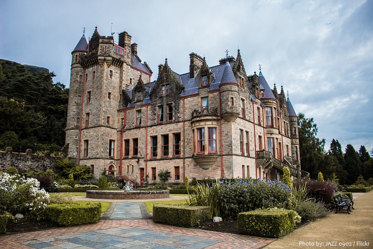
Belfast Castle is on the slopes of Cavehill Country Park in Belfast, Northern Ireland, in a prominent position 120 meters (400 feet) above sea level. Its location provides unobstructed views of the City of Belfast and Belfast Lough.
The Carrick-a-Rede Rope Bridge is a rope bridge near Ballintoy in County Antrim, Northern Ireland. The bridge links the mainland to the tiny island of Carrickarede. It spans 20 metres (66 ft) and is 30 metres (98 ft) above the rocks below. The bridge is mainly a tourist attraction and is owned and maintained by the National Trust.
The Dark Hedges is an avenue of beech trees along Bregagh Road between Armoy and Stranocum in County Antrim, Northern Ireland. The trees form an atmospheric tunnel that has been used as a location in HBO’s popular television series Game of Thrones, which has resulted in the avenue becoming a popular tourist attraction.

Tollymore Forest Park was the first state forest park in Northern Ireland, established on 2 June 1955. It is located at Bryansford, near the town of Newcastle in the Mourne and Slieve Croob Area of Outstanding Natural Beauty. It covers an area of 630 hectares (1,600 acres) at the foot of the Mourne Mountains and has views of the surrounding mountains and the sea at nearby Newcastle.
Northern Ireland is the least forested part of the United Kingdom and Ireland, and one of the least forested parts of Europe. Until the end of the Middle Ages, the land was heavily forested with native trees such as oak, ash, hazel, birch, alder, willow, aspen, elm, rowan, yew and Scots pine. Today, only 8% of Northern Ireland is woodland, and most of this is non-native conifer plantation.
Northern Ireland is sometimes referred to as Ulster, although it includes only six of the nine counties which made up that historic Irish province.
Cultural links between Northern Ireland, the rest of Ireland, and the rest of the UK are complex, with Northern Ireland sharing both the culture of Ireland and the culture of the United Kingdom.