Maryland is a state in the Mid-Atlantic region of the United States.
It is bordered by Pennsylvania on the north and by Chesapeake Bay and a small piece of Virginia on the south, Delaware and the Atlantic Ocean on the east, West Virginia and Virginia on the west.
As of June 2018, the population of Maryland was estimated to be 6,052,177. It is the 19th most populous state in the United States.
Maryland is the 42nd largest state in the United States in terms of total area with 12,407 square kilometers (32,135 square miles).
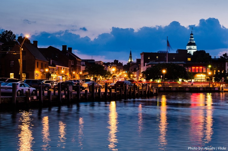
Annapolis is the capital of the U.S. state of Maryland. Situated on the Chesapeake Bay at the mouth of the Severn River, 25 miles (40 km) south of Baltimore and about 30 miles (50 km) east of Washington, D.C., Annapolis is part of the Baltimore–Washington metropolitan area.
Baltimore is the largest city in the state, the 30th-most populous city and the largest independent city in the United States. Founded in 1729, Baltimore is the second-largest seaport in the Mid-Atlantic. The Wire was set and filmed in Baltimore.
Maryland possesses a variety of topography within its borders, contributing to its nickname America in Miniature. It ranges from sandy dunes dotted with seagrass in the east, to low marshlands teeming with wildlife and large bald cypress near the Chesapeake Bay, to gently rolling hills of oak forests in the Piedmont Region, and pine groves in the Maryland mountains to the west.
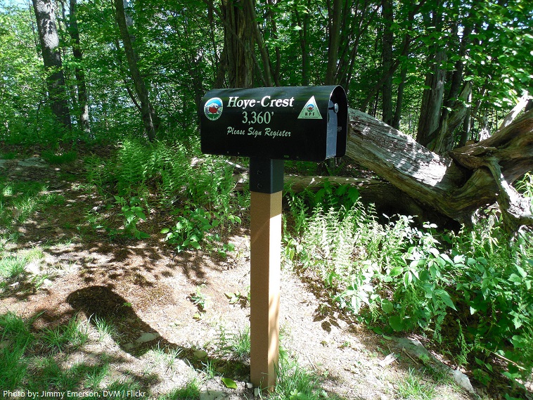
The highest point in Maryland, with an elevation of 1,020 meters (3,360 feet), is Hoye Crest on Backbone Mountain, in the southwest corner of Garrett County, near the border with West Virginia, and near the headwaters of the North Branch of the Potomac River.
Maryland has 18 national park and 72 state parks.
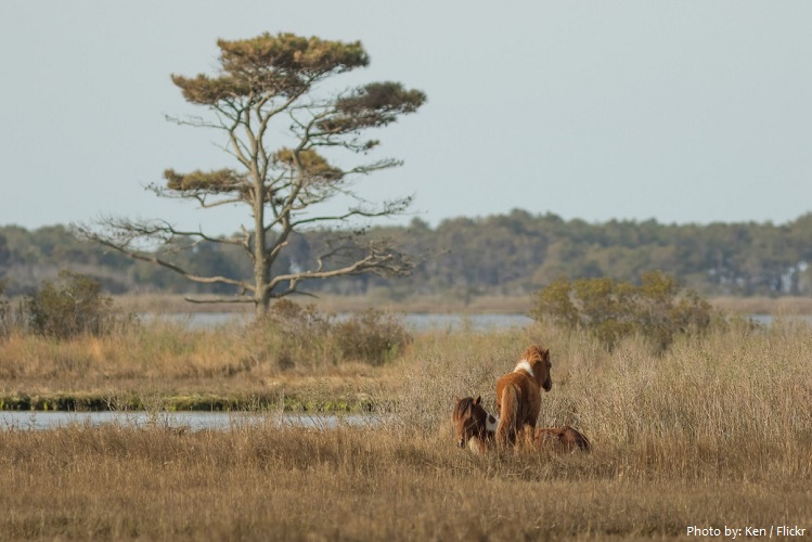
Assateague Island National Seashore is a National Park located on a barrier island on the Eastern Shore of the Delmarva Peninsula in Maryland and Virginia. The island is approximately 37 miles (60 km) long, yet never more than a mile wide. The park is divided into the Maryland District in the north and the Virginia District in the south.
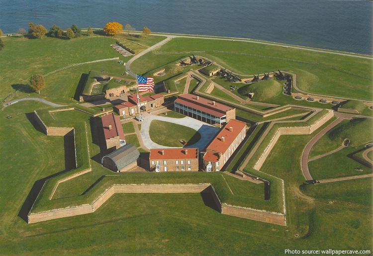
Fort McHenry is a historical American coastal pentagonal bastion fort located in the Locust Point neighborhood of Baltimore, Maryland. It is best known for its role in the War of 1812, when it successfully defended Baltimore Harbor from an attack by the British navy from the Chesapeake Bay on September 13–14, 1814. It was first built in 1798 and was used continuously by the U.S. armed forces through World War I and by the Coast Guard in World War II.
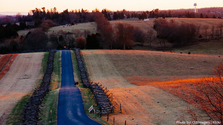
Antietam National Battlefield is a National Park Service protected area along Antietam Creek in Sharpsburg, Washington County, northwestern Maryland. It commemorates the American Civil War Battle of Antietam that occurred on September 17, 1862.
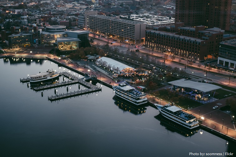
Inner Harbor in Baltimore is a sightseeing hub, home to Maryland Science Center with a planetarium and observatory, and the National Aquarium. The Top of the World Observation Level offers sweeping views of the city, while a collection of historic warships is docked below. Power Plant Live! is a complex of bars, eateries and music venues in a former power station.
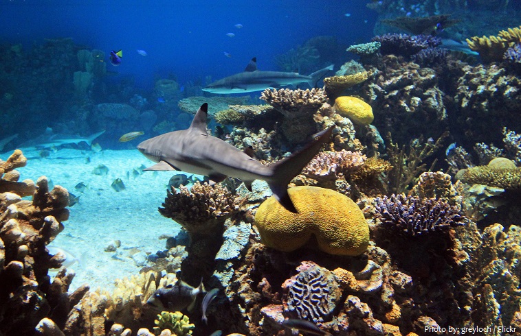
The National Aquarium is a non-profit public aquarium located at 501 East Pratt Street on Pier 3 in the Inner Harbor area of downtown Baltimore, Maryland. Constructed during a period of urban renewal in Baltimore, the aquarium opened on August 8, 1981. The aquarium has an annual attendance of 1.5 million visitors and is the largest tourism attraction in the State of Maryland. The Aquarium holds more than 8,300,000 litters (2,200,000 US gallons) of water, and has more than 17,000 specimens representing over 750 species.
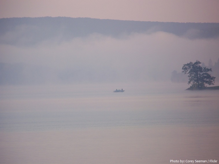
Deep Creek Lake is the largest inland body of water in the U.S. state of Maryland. It covers approximately 1,580 hectares (3,900 acres) and has 111 kilometers (69 miles) of shoreline. Like nearly all lakes in Maryland, it is man-made by the state The lake is home to a wide variety of freshwater fish and aquatic birds.
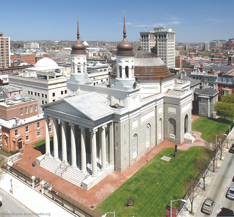
The Basilica of the Assumption of the Blessed Virgin Mary is considered a masterpiece and one of the finest 19th century buildings in the world. The basilica is the first cathedral in the United States. Baltimore represents the first Roman Catholic diocese.
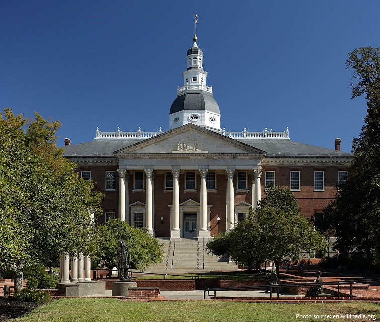
The Maryland State House is the oldest state capitol still in continuous legislative use and is the only state house ever to have served as the nation’s capitol. The capitol has the distinction of being topped by the largest wooden dome in the United States constructed without nails. The current building, which was designated a National Historic Landmark in 1960, is the third statehouse on its site. The building is administered by the State House Trust, established in 1969.
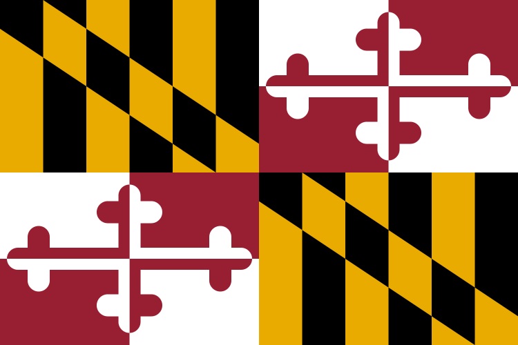
Maryland state flag is the only state flag in the United States to be based on English heraldry. The design is taken from the “escutcheon” or “shield,” in the first Lord Baltimore’s Seal, dating from the 1630s. Black and gold quarters are the arms of Lord Baltimore’s family, the Calverts. Red and white quarters are those of his mother’s family, the Crosslands.
It appears that the first humans in the area that would become Maryland arrived around the tenth millennium BC, about the time that the last ice age ended.
By 1000 AD, there were about 8,000 Native Americans, all Algonquian-speaking, living in what is now the state, in 40 different villages.
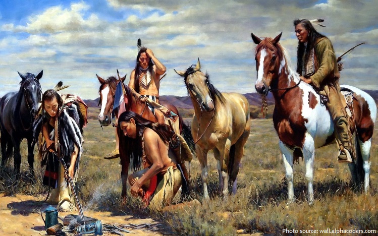
By the 17th century, the state was populated by a mix of Iroquoian and Algonquian peoples.
The recorded history of Maryland dates back to the beginning of European exploration, starting with the Venetian John Cabot, who explored the coast of North America for England in 1498.
In 1781, during the American Revolutionary War, Maryland became the thirteenth state of the United States to ratify the Articles of Confederation and Perpetual Union. It was later that same decade it became the seventh state to ratify the new U.S. Constitution in 1788.

Among its occasional nicknames are Old Line State, the Free State, and the Chesapeake Bay State. The state is named after the English queen Henrietta Maria of France.
Maryland forests cover approximately 1 hectares 2.7 million acres, basically 43% of the states land surface. Oak and hickory are the dominant hardwood or deciduous forest type, making up 60% of forested areas. Loblolly pine is the most prevalent softwood and is the predominant forest wood on the Eastern Shore.
Maryland is the leading producer of blue crabs and is renowned for its crab cakes.